


|
|
Copyright © 1995,1996,1997 by Rosanna L. Hamilton. All rights reserved.
| Introduction |
|---|
Caldera in the Spanish language means "kettle" or "cauldron"; in geological literature, it has come to be known as a volcanic collapse crater. Craters are the vents through which cinders, ash, lava and other ejected materials are erupted, and thus are related to cone building. Craters are usually formed by deposition around a volcanic vent and enlarged by the slumping of unstable deposits into the vent. Calderas, on the other hand, are formed when infrequent, truly large eruptions occur and the gas-rich magma is quickly erupted from depths of 4 to 6 kilometers (2.5 to 3.7 miles). The remaining void space from which the magma was drained results in a piston-like collapse of the overlying rocks. This, in turn, opens up many vents and the eruption continues as the piston collapses. The resulting collapse crater is mostly filled with its own volcanic ash and pumice. Calderas are known to have diameters ranging from less than 1.6 kilometers (1 mile) to more than 48 kilometers (30 miles). Large calderas are usually formed during a collapse that truncates an entire volcanic field, not just one large cone.
The Valles caldera of New Mexico is a beautiful example of a resurgent caldera located in the midst of the Jemez volcanic field. Scientists study this area to learn about the fundamental processes in magmatism, hydrothermal systems, and ore deposition. With nearly 40 deep wells which have resulted in extensive subsurface data, the Valles caldera is the best explored caldera complex in the United States. It is the youngest of two calderas in the region, having collapsed over and buried the Toledo caldera (which might have collapsed over older calderas.) These two large eruptions took place 1.4 million and 1 million years ago. The circular topographic expression of the Valles caldera measures 22 kilometers (14 miles) in diameter.The Jemez volcanic field, including the calderas, lies above the intersection of the Rio Grande rift, which runs north-south through New Mexico, and the Jemez lineament, which extends from southeastern Arizona northeast to the westernmost part of Oklahoma. The volcanic activity is related to the tectonic movements along this intersection.
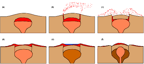
The evolution of a resurgent caldera begins when gas-rich magma collects near the roof of a magma chamber bulging under older volcanic rocks (a). After an eruption begins and collapse is initiated, ring shaped fractures propagate out of the chamber and burst to the surface, creating a vent for steam and gas. Decompressing gases and jets of pumice and ash follow at high speeds into the atmosphere (b). The upper part of the magma chamber froths, expands and flows up the vent. The velocity decreases as magma from the deeper parts of the chamber begin to flow out and the rocks overlying the magma begin to collapse along the fractures into the now emptied chamber (c). Pyroclastic flows continue as the initial burst of ash and deeper parts of magma flow across the surface covering the caldera and surrounding geographic area (d). The magma chamber is then depleted in gases and minor volcanic activity can persist along the ring fracture for as much as a million years. The crater is then mostly filled with volcanic ash and pumice and is quickly occupied by a crater lake (e). This flat-floored crater doesn't stay this way for long; the magma, now depleted in gases, continues to slowly rise. The crater floor is pushed up as much as 1 kilometer (.6 miles), forming a giant "blister." In the case of the Valles caldera, this giant "blister" is Redondo Peak, which is 1 kilometer (.6 miles) above the present day caldera floor. Large resurgent calderas are among the most destructive natural catastrophes on Earth. Krakatoa (Indonesia) and Taal (Philippines) are two examples of cataclysmic events. Other resurgent caldera examples are Long Valley caldera in California, Yellowstone caldera in Wyoming, and Toba caldera in northern Sumatra. Olympus Mons on Mars is the largest and most spectacular caldera ever discovered.
The fragmentary materials ejected from a volcano--rock, mineral, and glass--are called pyroclasts and are classified according to size. Gas is also a part of the pyroclastic flow. Dust is made of the finest fragments and ash is about the size of sand, which measures up to 2 millimeters (.08 inches). Bombs are chunks larger than about 6 centimeters (2.4 inches), ranging from the size of a baseball to the size of a basketball. Extremely large bombs are called boulders, blocks or blockbusters; some as heavy as 100 metric tons (90 tons) have been thrown more than 10 kilometers (6 miles) in violent eruptions. After the pyroclasts settle, the deposit areas lithify and become cemented together. This occurs easily because the fragments are typically still hot and therefore soft when compacted or welded together; the fragments take decades to cool. The resulting rocks formed by the smaller pyroclasts are called tuffs. The lower Bandelier tuff which can be seen along canyon walls west of the Valles caldera, including San Diego canyon, is related to the eruption and collapse of the Toledo caldera. The upper Bandalier tuff is believed to have been deposited during eruption and collapse of the Valles caldera. The now eroded and exposed orange-tan, light colored Bandelier tuff from these events create the stunning mesas of the Pajarito Plateau.
| Views of the Valles and Other Calderas |
|---|
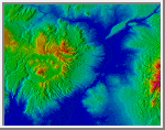
Shaded Elevation Map of the Valles Caldera
The lowlands (blue) are within the Rio Grande rift; the Jemez volcanic
field (with the circular depression in the middle) sits astride the
western rift boundary. The green patch immediately east of the Jemez
volcanic field is the Cerros del Rio, a mid-rift basaltic volcanic field.
(Credit: Calvin J. Hamilton)
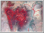 Landsat Image of the Valles Caldera
The straight line on the left is the Nacimiento faults, a boundary
between the Precambrian rocks of the San Pedro Parks and the
sedimentary rocks of the San Juan basin. This false-color Landsat image
has dry areas as grey-brown and wooded areas as red. The flat plateaus
around the Valles caldera (center) are canyons within the Bandelier Tuff.
(Courtesy LANL/NASA)
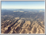 Los Alamos and Pajarito Plateau
This view is looking west across the dissected Bandelier Tuff of the
Pajarito Plateau. The view looks across the lava domes and composite
cones of the pre-2-million-year Jemez volcanic field (middle) into the
Valles caldera. The grassy area, located at the center top, is the
southeast quarter of the caldera. Los Alamos, New Mexico is in the
foreground.
(Courtesy LANL)
 Long Valley Caldera
This is three-dimensional perspective view of Long Valley,
California. Blue areas in the image
are smooth and yellow areas are rock outcrops with varying
amounts of snow and vegetation. The view is looking north
along the northeastern edge of the Long Valley caldera, a
volcanic collapse feature created 750,000 years ago and the
site of continued subsurface activity. Crowley Lake is the
large dark feature in the foreground. The ridge of mountains that
runs towards the top of the image is the northeast rim of the
Long Valley Caldera.
(Courtesy NASA/JPL)
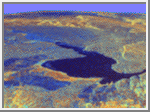
 Taal Volcano, Philippines
This is an image of Taal volcano, near Manila on the island
of Luzon in the Philippines. The black area in the center is
Taal Lake, which nearly fills the 30-kilometer-diameter (18-
mile) caldera. The caldera rim consists of deeply eroded
hills and cliffs. The large island in Taal Lake, which
itself contains a crater lake, is known as Volcano Island.
The bright yellow patch on the southwest side of the island
marks the site of an explosion crater that formed during a
deadly eruption of Taal in 1965. The image is
centered at 14.0 degrees north latitude
and 121.0 degrees east longitude. North is toward the upper
right of the image. Since
1572, Taal has erupted at least 34 times. Since early 1991,
the volcano has been restless, with swarms of earthquakes,
new steaming areas, ground fracturing, and increases in
water temperature of the lake. The bright area in
the upper right of the image is the densely populated city
of Manila, only 50 kilometers (30 miles) north of the
central crater.
(Courtesy NASA/JPL)
| References |
|---|
Bailey, R. A., R. L. Smith, C. S. Ross. "Stratigraphic nomenclature of volcanic rocks in the Jemez Mountains, New Mexico." US Geol. Surv. Bull., 1969.
Bullard, Fred M. Volcanoes of the Earth. University of Texas Press, Austin & London, 1976.
Heiken, Grant et al. "The Valles/Toledo Caldera Complex, Jemez Volcanic Field, New Mexico." Annu. Rev. Earth Planet Sci., 18:27-53, 1990.
Press, Frank and Raymond Siever. Earth. New York: W. H. Freeman and Company, 1986.
Smith, R. L., R. A. Bailey. "Resurgent caulderons." Geol. Soc. Am. Mem., 116: 613-62, 1968.

 Terrestrial Volcanoes